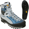
 Well, I think I have to bite the bullet and just upgrade to a full mountaineering boot. I have been looking at getting these Scarpa's but I'm not sure yet. Any recommendations?
Friday, April 27, 2012
Time to Upgrade
Well, I think I have to bite the bullet and just upgrade to a full mountaineering boot. I have been looking at getting these Scarpa's but I'm not sure yet. Any recommendations?
Friday, April 6, 2012
My Review of Android Jacket - Men's
Mountain Hardwear Android Softshell Jacket - Men's Black, L
Great around town jacket
Pros: Durable, Well Constructed, Great Value
Cons: Doesn't breathe, Heavy
Best Uses: Around town, Outdoors
Describe Yourself: Enthusiast
Was this a gift?: No
Originally submitted at Mountain Gear

The Android Jacket from Mountain Hardwear is a flexible mountain town companion that can take you from work to the trail and to the pub at the end of the day. Clean, stylish, and athletic, the Android is constructed with elastane-aided polyester for flexibility and range of motion. When the wind st...
Great around town jacket
By Kain from Glacier Fresh from Sheridan, Or on 4/6/2012
Cons: Doesn't breathe, Heavy
Best Uses: Around town, Outdoors
Describe Yourself: Enthusiast
Was this a gift?: No
This is a great around town jacket. I really wish it wouldn't get so hot but it just doesn't seem to breathe so I can't take it on any trails that will require a lot of exertion anymore. It also seems a little short for my torso, as I have to tuck in any shirts I wear under it.
(legalese)
My Review of PreCip Jacket - Men's
Marmot PreCip Jacket - Men's Cobalt Blue, XL
Inexpensive yet powerful
Fit: Feels true to size
Sleeve Length: Feels true to length
Chest Size: Feels true to size
Pros: Stylish, Comfortable, Lightweight, Durable, Breathable, Waterproof
Cons: Not Windproof
Best Uses: Wet Weather, Hiking and Camping, Cold Weather, Casual Wear
Describe Yourself: Avid Adventurer
Was this a gift?: No
Originally submitted at Mountain Gear

Combat the wettest conditions in the world with the time-tested PreCip Jacket from Marmot that keeps you dry with waterproof, lightweight Dry Touch technology. You're protected by a full-visibility, roll-up hood with Peripheral Cord adjustment and lightweight, seam-taped PreCip fabric that shun...
Inexpensive yet powerful
By Kain from Glacier Fresh from Sheridan, OR on 4/6/2012
Sleeve Length: Feels true to length
Chest Size: Feels true to size
Pros: Stylish, Comfortable, Lightweight, Durable, Breathable, Waterproof
Cons: Not Windproof
Best Uses: Wet Weather, Hiking and Camping, Cold Weather, Casual Wear
Describe Yourself: Avid Adventurer
Was this a gift?: No
I wear this jacket almost daily to prevent getting wet. It is great and I have only had to treat it once so far. I fold it into it's own pocket when I go mountaineering/hiking. When and if this one gets ruined or damaged I will most likely buy another one.
(legalese)
Thursday, April 5, 2012
South Sister 10358' - South Side (09-16-11)
 |
| The South Sister stands at 10,358'. |
On my second attempt for a "big summit" I found myself down in the Three Sisters Wilderness sizing up the largest and youngest of the three. At 10,358' the South Sister is the safest and most climbed. There is no technical ability required to reach the summit in the summer, only determination, patience, and strong legs.
On the day before attempting South Sister we set up camp at the Devil's Lake Campground. Admittedly, we were so set on climbing mountain's that we forgot to look at the lake itself! We decided to take a nice short day hike over to "The Wife" (will write something on this later) where I snagged the picture above.
 |
| Headlamps are the way to go. |
 |
| Broken Top during sunrise. |
Our hike up continued and members in our party were having a difficult time so while it slowed us down, it also gave us time to appreciate our surroundings more. I couldn't help myself and kept turning around to see Mt. Bachelor and the valley getting further and further away.
 |
| Mt. Bachelor above the blanket of fog in the valley. |
 |
| Fresh lake near Lewis Glacier |
 |
| 10,000' and loving it |
This is the steepest portion of the trail and as you reach altitude you may start feeling it's effects. We happened to get ahead of the rest of our party so I figured I would celebrate crossing the 10,000' mark for the first time by posing for a shot.
Once you reach the false summit, you have another 1/4 to 1/2 mile left. You can cross the glacier or walk around the ridge to the true summit. You will notice rock structures made by climbers to deal with wind. I was really hoping to see Teardrop Pool, which forms in the crater, but it never showed in 2011 so we weren't able to see "Oregon's Highest Lake". From the summit you can enjoy views of Middle and North Sister, Broken Top, Mt. Bachelor, Mt. Washington, Mt. Jefferson, Mt. Hood, Mt. Saint Helens, and Diamond Peak.

Final Stats:
Summit: YesElevation Gain: ~5000'
Round Trip Distance: 12.4 miles
Round Trip Time: 12 hours
Tuesday, April 3, 2012
Mount St. Helens 8365' - Monitor Ridge (07-27-11)
 |
| View from the top |
 |
| First sight of the mountain |
Nostalgia aside, gearing up for the trip was fairly easy. I ended up waiting too long to get my climbing permit from Mount St. Helens Institute so instead I had to buy them from a user on the Cascade Climber Forums. They are $22 a piece and needed when attempting the summit. We signed into the Lone Fir Resort in Cougar, Washington and pitched tents at the Climber's Bivouac.
We started out our day at roughly 5am and spent the 2.1 miles following the Ptarmigan Trail. Just before you break out above the treeline there is a restroom. I recommend using it now as you will most likely have to bluebag it after this point. We had a rough time figuring out where the trail started due to foggy conditions and no footprints. Make sure you keep a compass/map handy and know how to use it. We eventually found a marker in a tree and from there forward there was nice wooden posts most of the way up indicating the trail.
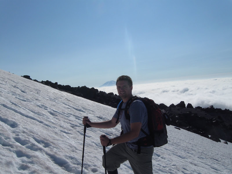 |
| Halfway up! |
 |
| Monitor on Monitor Ridge |
We enjoyed our time at the top and even traded some trash bags for a nice cold beer. After getting our summit photos and having a much needed lunch we decided to put on some trash-bag diapers and glissade down. We accidentally glissaded too far west despite multiple warnings at the Lone Fir Resort/Cafe. This left us to scramble back over to monitor ridge across several nasty loose volcanic rocky ridges. Lesson learned! Make sure you know where you are glissading to.
I also learned that you should always apply sunscreen liberally. I was absolutely toasted after this trip and hurt for several days. It took away part of my experience that night when I finally got home.
Final Stats:
Summit: YesElevation Gain: 4565'
Round Trip Distance: 11.6 miles
Round Trip Time: 12 hours
FULL GALLERY
 |
| On top of the world |
Sunday, April 1, 2012
A Fresh Start
Hello!
This is my first post of course. I will make an official introduction later. This is basically a site to track my mountaineering accomplishments, review gear, and provide great original pictures/stories along the way.
This is my first post of course. I will make an official introduction later. This is basically a site to track my mountaineering accomplishments, review gear, and provide great original pictures/stories along the way.
Subscribe to:
Comments (Atom)